- Esri Navigation
-
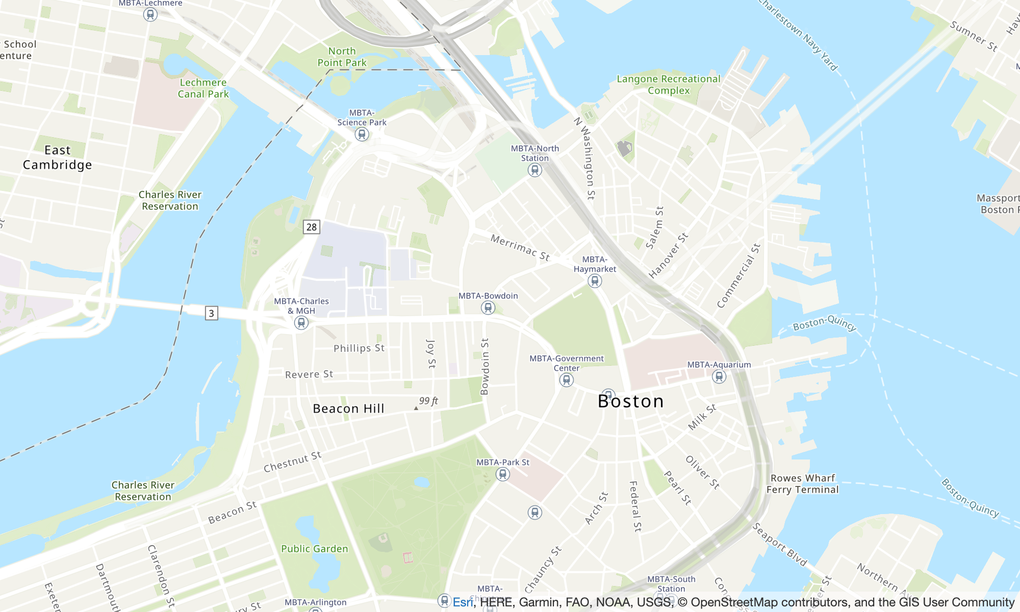
Esri Navigation
Map style name:
VectorEsriNavigation
This map provides a detailed basemap for the world symbolized with a
custom navigation map style that's designed for use during the day in mobile
devices.
This comprehensive street map includes highways, major roads, minor roads,
railways, water features, cities, parks, landmarks, building footprints, and
administrative boundaries. The vector tile layer in this map is built using
the same data sources used for the World Street Map and other Esri
basemaps. Enable the POI layer by setting it in CustomLayers to leverage the additional places data.
For more information, see Esri World Navigation on the Esri website.
TheVectorEsriNavigation map pictured above has the POI
layer enabled.
Fonts
Amazon Location serves fonts using GetMapGlyphs. The following are available font
stacks for this map:
-
Arial Italic
-
Arial Regular
-
Arial Bold
-
Arial Unicode MS Bold
-
Arial Unicode MS Regular
- Esri Imagery
-
Esri Imagery
Map style name:
RasterEsriImagery
This map provides one meter or better satellite and aerial imagery in many
parts of the world and lower resolution satellite imagery worldwide.
The map includes 15m imagery at small and mid-scales (~1:591M down to
~1:72k) and 2.5m SPOT Imagery (~1:288k to ~1:72k) for the world. The map
features 0.5m resolution imagery in the continental United States and parts
of Western Europe from Maxar. This map features additional Maxar submeter
imagery in many parts of the world. In other parts of the world, the GIS
User Community has contributed imagery at different resolutions. In select
communities, very high-resolution imagery (down to 0.03m) is available down
to ~1:280 scale.
For more information, see Esri World Imagery on the Esri website.
- Esri Light
-
Esri Light
Map style name:
VectorEsriTopographic
This provides a detailed basemap for the world symbolized with a classic
Esri map style. This includes highways, major roads, minor roads, railways,
water features, cities, parks, landmarks, building footprints, and
administrative boundaries.
This basemap is compiled from a variety of authoritative sources from
several data providers, including the US Geological Survey (USGS), US
Environmental Protection Agency (EPA), US National Park Service (NPS), Food
and Agriculture Organization of the United Nations (FAO), Department of
Natural Resources Canada (NRCAN), HERE, and Esri. Data for select areas is
sourced from OpenStreetMap contributors. Additionally, data is provided by
the GIS community.
Fonts
Amazon Location serves fonts using GetMapGlyphs. The following are available font
stacks for this map:
- Esri Light Gray Canvas
-
Esri Light Gray Canvas
Map style name:
VectorEsriLightGrayCanvas
This map provides a detailed basemap for the world symbolized with a light
gray, neutral background style with minimal colors, labels, and features
that's designed to draw attention to your thematic content.
This vector tile layer is built using the same data sources used for the
Light Gray Canvas and other Esri basemaps. The map includes highways, major
roads, minor roads, railways, water features, cities, parks, landmarks,
building footprints, and administrative boundaries.
For more information, see Esri Light Gray Canvas on the Esri website.
Fonts
Amazon Location serves fonts using GetMapGlyphs. The following are available font
stacks for this map:
-
Ubuntu Italic
-
Ubuntu Regular
-
Ubuntu Light
-
Ubuntu Bold
- Esri Street Map
-
Esri Street Map
Map style name:
VectorEsriStreets
This map provides a detailed basemap for the world
symbolized with a custom navigation map style that's designed for use during the day
in mobile devices.
This comprehensive street map includes highways, major roads, minor roads, railways,
water features, cities, parks, landmarks, building footprints, and administrative boundaries.
It also includes a richer set of places, such as shops, services, restaurants,
attractions, and other points of interest.
The vector tile layer in this map is built using the same data sources used for the World Street Map and other Esri basemaps.
For more information, see Esri World Street on the Esri website.
Fonts
Amazon Location serves fonts using GetMapGlyphs. The following are available font
stacks for this map:
-
Arial Italic
-
Arial Regular
-
Arial Bold
-
Arial Unicode MS Bold
-
Arial Unicode MS Regular
- Esri Dark Gray Canvas
-
Esri Dark Gray Canvas
Map style name:
VectorEsriDarkGrayCanvas
This map provides a detailed vector basemap for the world symbolized with
a dark gray, neutral background style with minimal colors, labels, and
features that's designed to draw attention to your thematic content.
This map includes highways, major roads, minor roads, railways, water
features, cities, parks, landmarks, building footprints, and administrative
boundaries. The vector tile layers in this map are built using the same data
sources used for the Dark Gray Canvas raster map and other Esri
basemaps.
For more information, see Esri Dark Gray Canvas on the Esri website.
Fonts
Amazon Location serves fonts using GetMapGlyphs. The following are available font
stacks for this map:
-
Ubuntu Medium Italic
-
Ubuntu Medium
-
Ubuntu Italic
-
Ubuntu Regular
-
Ubuntu Bold